The Synthiam Robot Skill Store is where you discover new robot skills for ARC robot programming software. Install ready-made skills for AI, vision, navigation, speech recognition, servos, and more to quickly expand what your robot can do — whether it's a DIY project, an education robot for the classroom, or an enterprise product.
You can also publish your own robot skills for the community or learn how to add existing skills to your robot projects.
 Create a Robot Skill
 What is a Robot Skill?
Most Recent
Adc
Artificial Intelligence
Audio
Camera
Communication
Digital
Display
Games
General
Gps
Graphs
I2c
Infrared Distance
Misc
Movement Panels
Navigation
Power
Pwm
Rafiki
Remote Control
Scripting
Servo
Ultrasonic
Virtual Reality
The Navigation category in Synthiam ARC is dedicated to enabling robots to navigate and move autonomously. It includes functionalities such as path planning, obstacle avoidance, and localization. This skill set is crucial for developing robots capable of exploring and navigating complex environments.
BN-880 GPS Compass v2

Standalone autonomous navigation using Beitian BN-880 GPS/Compass with real-time map waypointing and offline map caching; requires Arduino.
Camera NMS Pose v8

Overhead camera tracks a glyph to give precise robot pose to ARC's NMS for multi-camera indoor/outdoor navigation and waypoint control
EZ-SLAM v25

Creates a map in a global variable; proof-of-concept SLAM visualizer (very experimental).
Hitachi-LG LDS Lidar v22
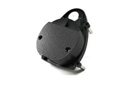
Hitachi-LG LDS 360-degree LiDAR driver streaming scans into ARC NMS for obstacle detection, SLAM use, Arduino hookup, config options and variables.
Indoor Positioning System v16

Infrared indoor positioning for ARC robots: dual-camera tracks IR beacon, shows real-time heading, path and EZ-Script navigation variables
Intel Realsense D435i v20
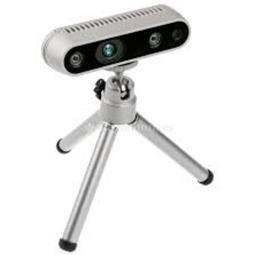
Connect Intel RealSense depth cameras to ARC NMS for depth-based distance detection, point-cloud mapping, video streaming, and navigation telemetry.
Intel Realsense T265 v26
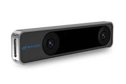
T265 VSLAM for ARC: SLAM-based mapping and precise way-point navigation, low-power tracking, and NMS telemetry.
Kinect Xbox 360 Depth Mapping v6
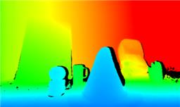
Converts Xbox 360 Kinect depth frames into NMS obstacle scans for ARC path planning, SLAM, and obstacle avoidance.
NMS Example v3

Example NMS Level #1 navigation skill showing subscription to combined scan+location data, displaying position and scan info; source code included.
NMS Faux Odometry v8

Estimate pose odometry from movement distance for robots without encoders, calibrated by speed. Suited for DIY navigation; pose drifts with lidar.
NMS Navigation Data Grabber v2

Query NMS lidar scan data by angle, with control commands for range, arc extremes, and obstacle checks from the latest scan.
PTI Lidar Plugin v2

Pineapple Technology Industries Capstone plugin adds a secretive LiDAR unit to ARC for distance measurement.