
ptp
USA
Asked
How To Use T265 With A Lidar?
Hello guys.
I'm trying to setup a base template project to use T265 and Lidar Plugins. Can someone share a project or scripts to navigate and use the Lidar data to avoid the obstacles ?

Hello guys.
I'm trying to setup a base template project to use T265 and Lidar Plugins. Can someone share a project or scripts to navigate and use the Lidar data to avoid the obstacles ?
What lidar? The hitachi lgs? https://synthiam.com/Support/Skills/Navigation/Hitachi-LG-LDS-Lidar?id=20086
use The Navigator robot skill for the nms: https://synthiam.com/Support/Skills/Navigation/The-Navigator?id=20072
Unless you want to get the core slam or hector slam built as a robot skill: https://github.com/mikkleini/slam.net
that author also did a good c# a path planning port that’s great.
The navigator will execute scripts and stop navigation based on detected object. It doesn’t do path planning. See my previous response about path planning by that author. He did a good job porting to c#
the navigator robot skill page has info on how it works with the nms. But I suspect you’ll figure it out without needing to read it
in your example usage case - the t265 publishes Cartesian coordinates to the nms. The lidar publishes distance data as a laser scan to the nms. The navigator subscribes to the NMS and uses both of those datas to create a map and plot paths and way points. The navigator uses the ARC Movement Panel service to control the robot with what ever Movement Panel is installed in the project.
@DJ and @ptp Nice project by mikkleini, just what we need. Could that hector slam and path planning be integrated in The navigator?
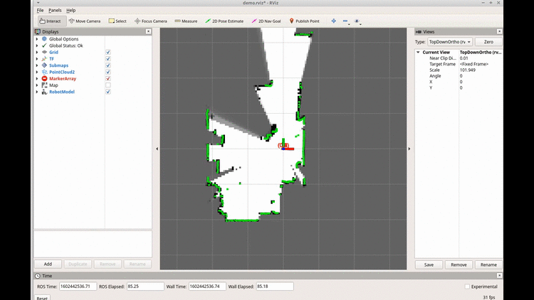
Regarding SLAM I'm still using the gmapping (https://wiki.ros.org/gmapping) with encoders (odometry) and IMU (EKF fused odometry) and lidar data for robot localization (monte carlo). There are at least 2 interesting options :
I'm trying to stay close to the ARC path with the existing plugins.
I don’t think either would be integrated into the navigator. They’d work best as their own robot skills. That way they could work together. If too much is built into a single skill then it limits the flexibility.
Currently i am trying to use my Roomba with ROS Kinect and later integrate my Ylidar X2 that i bought. I am still waiting for the lidar to test it with ARC. ptp, isnt there a topic in ROS that we could use to send and receive coordinates from Rviz to ARC? We could have a Rpi or Jetson Nano handling navigation with ROS and a sbc running ARC.