jstarne1
How Can I Use GNSS RTK + IMU To Record And Set A Perimeter?
Hello all, looking for some help. How can I use a GPS GNSS RTK module to record a parameter for a lawn mowing robot? Then once perimeter is set, the robot sees this as a geo fence barrier so that the robot does not need boundary wires. Also how can I utilize two GPS units, one for the base station and one for the rover?
This video shows exactly what I want to do. Drive robot and define parameter using robots gps, then mows within this boundary. https://m.youtube.com/watch?v=BSF04i3zNGw
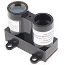
ZED F9P Ublox is the gps Gnss RTK unit I am looking at for cm range accuracy.
I can post a few examples being done with arduino or ardupilot for example, not for the purpose of promoting other softwares , but just as reference to understand what I am wanting to do as well as other projects that have some kind of working code examples.
It would be awesome to have a mapping tool specifically using the GNSS RTK module and IMU to set the boundary, mark obstacles and then set a path in rows the robot follows while mowing.
one version that uses a tool to create gps points then load them into a mission. I would like to do this with synthiam.
Here are some other examples, but the first video really nails the primary goal I am looking for.
https://deepsouthrobotics.com/2019/07/10/meet-precision-mule/
ardumower sunray https://main.grauonline.de/ardumower-sunray-app-companion-ardumower-rtk/
https://m.youtube.com/watch?v=aGlD8L36CxE
Related Hardware (view all EZB hardware)

GPS? That’ll be super inaccurate but okay. The trouble with gps is you also need compass. The imu can be used instead I guess.
You can use the arduino solution to get the Cartesian coordinates and pump them into the nms. Then you can use the better navigator for managing way points.
or just run the arduino solution with a connection to ARC for status, start/stop, and location display.
Besides GNSS RTK CM gps, what’s your suggestion?
Marked as resolved
Hmmm not sure. Id have to take a look at what others have done. Something like this is quite specific. Most navigation is indoors using lidar and such. So an outdoor gps driven one is a little different and requires a different sensors
the accuracy of gps is very low. Also because heading direction can only calculated by previous way points, another sensor such as a compass is needed.
I feel that if another solution does a good job at it, that we should integrate that. ARC doesn’t have to be the brains behind a solution, if there’s already something working. ARC can be an interface that compliments the solution by providing extensibility & user friendliness
Have you seen this guy's setup? https://www.notebookcheck.net/The-OpenMower-is-a-Raspberry-Pi-and-ArduSimple-based-robotic-lawn-mower-that-you-can-build-yourself.613269.0.html